
Introduction:
Land surveying is a foundational aspect of civil engineering, providing critical data and insights for planning, designing, and constructing infrastructure projects. Traditional surveying methods, while effective, are often time-consuming and labour-intensive. However, with advancements in technology, modern surveying techniques have emerged, revolutionizing the field and offering unprecedented levels of precision, efficiency, and accuracy. In this blog, we explore some of the modern techniques for land surveying in civil engineering, highlighting their benefits and applications.
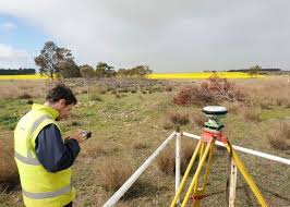
1. Global Navigation Satellite System (GNSS):
– GNSS, including the Global Positioning System (GPS), GLONASS, and Galileo, enables precise positioning and navigation through a network of satellites orbiting the Earth.
– GNSS receivers capture signals from multiple satellites to determine the receiver’s position in three-dimensional space, allowing surveyors to accurately measure distances, elevations, and coordinates.
– GNSS technology has transformed land surveying by providing real-time positioning data, streamlining fieldwork operations, and enhancing surveying accuracy, particularly in large-scale projects such as highway construction and urban development.
2. Terrestrial Laser Scanning (TLS):
– TLS, also known as LiDAR (Light Detection and Ranging), utilizes laser pulses to measure distances and create detailed three-dimensional representations of terrain, structures, and objects.
– TLS scanners emit laser beams that reflect off surfaces and return to the sensor, allowing for the precise measurement of distances and the generation of high-resolution point clouds.
– TLS technology offers rapid data acquisition, high spatial resolution, and wide area coverage, making it ideal for applications such as topographic mapping, volumetric analysis, and as-built documentation in civil engineering projects.
3. Unmanned Aerial Vehicles (UAVs) or Drones:
– UAVs, equipped with cameras, LiDAR sensors, and GPS receivers, offer a versatile platform for aerial surveying and mapping applications.
– Drones capture high-resolution imagery and LiDAR data from various altitudes, enabling surveyors to create detailed maps, orthophotos, and digital surface models (DSMs) of terrain and infrastructure.
– UAV-based surveying is cost-effective, efficient, and scalable, allowing for rapid data collection and analysis in remote or inaccessible areas, such as construction sites, mining operations, and natural disaster zones.
4. Ground-Penetrating Radar (GPR):
– GPR is a non-destructive geophysical technique that uses electromagnetic waves to image subsurface features, such as utilities, foundations, and geological structures.
– GPR systems emit radar pulses into the ground and measure the time it takes for the signals to reflect back from buried objects or interfaces, providing information about their depth, location, and composition.
– GPR technology is invaluable for utility mapping, archaeological surveys, and geotechnical investigations, helping to identify underground hazards and inform engineering design decisions.
5. Mobile Mapping Systems (MMS):
– MMS combines various sensors, including GNSS receivers, inertial measurement units (IMUs), cameras, and LiDAR scanners, mounted on vehicles or backpacks, to collect geospatial data along transportation corridors or urban environments.
– MMS platforms capture synchronized data streams from multiple sensors, allowing for the simultaneous mapping of terrain, infrastructure, and surroundings with high accuracy and efficiency.
– MMS technology facilitates asset management, transportation planning, and infrastructure maintenance activities by providing detailed spatial information and 3D models of the built environment.
Conclusion: